Geodesy
What is Gravitation? - From the Apple ...
Knowing more about the gravitational field of the Earth can improve our lives, and help us to grow and to benefit both economically and socially. It helps us understand climate change, sea level rise, and geologic hazards (earthquakes, volcanoes); and it makes possible practically all satellite applications, as well as precise navigation systems.
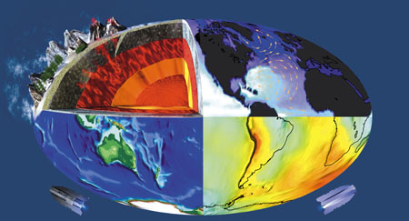
Since our planet is made of different materials, its gravitational field shows local variations (called anomalies). Observing these anomalies can help us to explore the subsurface mass distribution of our planet. In this way we may look into the interior of the Earth.
What affects the gravitational field?
- mass density variatons inside the Earth;
- the oceans - the level of oceans changes due to temperature, ocean currents, etc. Changes in the level of oceans change the gravitational field, too.
- the Sun, Moon and other planets - the gravitational effects of the planets vary according to their position relative to the Earth.
- ice sheets - they compress the Earth's crust beneath them. Changes in the ice caps (e.g. melting due to the greenhouse effect) may reduce this compression, thus the gravitational field changes.
These effects are only examples. However we can see how complicated our planet is, and how these components interact with each other. In the first Section we defined Geodesy as a science of studying the shape, size and gravitational field of the Earth. But what is the gravity field, and why is it important?
What is Gravitation? - From the Apple ...
Gravitation in a nutshell
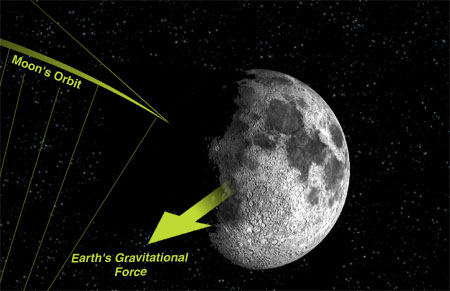
Gravitation is a force that pulls or attracts all bodies in the universe towards each other because they have mass. Planets remain in their orbits around the Sun due to this force. The gravitational force depends on the amount of mass of the bodies. In Geodesy, we usually distinguish “gravity” as gravitation plus centrifugal acceleration due to Earth's rotation because traditionally we can measure gravity, not gravitation, at points on the rotating Earth.
Newton's Apple
Sir Isaac Newton proposed that Earth's gravitation causes such things as the fabled apple to fall and is the same force that keeps planets in their orbits. For example, he figured out that the Moon would travel in a straight line without the attraction from the Earth pulling it into a curved path (the orbit).
What is Gravitation - ... To the Satellites
Why do we need to study the gravitational field?
Gravitation affects almost everything in our lives. From precise clocks to hydroelectric dams, from the tides of the oceans to blood circulation.
We study the Earth's gravitational field to learn more about our planet. This knowledge can lead us to new ways of doing everyday things with greater awareness towards sustainability of our environment for future generations.
How can the satellites help?
If we want to study the gravitational field globally, terrestrial gravity measurements have some huge limitations, mostly because they do not cover the whole globe homogeneously. Moreover, in some places of the world, these observations are highly confidential because gravity measurements lead exploration geophysicists to oil fields and allow military planners to guide missles.
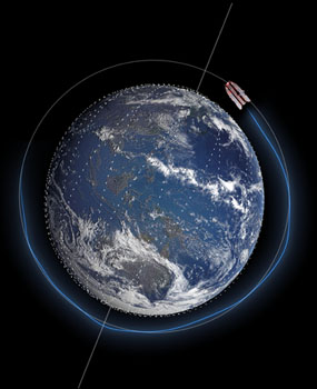
Satellite missions such as CHAMP, GRACE and GOCE help us to study the global gravitational field of the Earth. These Low-Earth Orbiters (LEOs) provide us a global, homogeneous coverage of gravitational observations.
Geodesy and the Society
Geodesy is in a transition due to the fact that the advent of space-geodetic techniques and the rapid improvement of communication techniques and capacities have fundamentally changed, if not revolutionized, geodesy and its methods. While previously point coordinates were given with respect to local or regional reference frames, with space geodetic techniques positions can now be observed with respect to a global reference frame with unprecedented accuracy. Based on these techniques, changes in Earth's shape, rotation and gravity field are provided with increasing spatial and temporal resolution, increasing accuracy, and with decreasing latency.
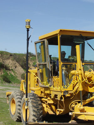
The societal prospects of space geodesy are fundamental. The technological development facilitated through the new space-geodetic techniques for navigation and positioning poses new and difficult challenges and continuously creates new requirements in terms of accessibility, accuracy and long-term stability. The rapid development of satellite-based precise point positioning techniques, which allows the determination of very accurate position anytime and anywhere on the planet, enables a wide range of position-related applications. The new geodetic technologies are leading to fundamental changes not only in all areas of navigation and transport, but also for application in process control (e.g. farming, construction, mining, resource management), construction and monitoring of infrastructure (e.g. off-shore platforms, reservoirs dams, bridges, and other large civil structures), surveying and mapping (including off-shore), and Earth observation. Geodetic techniques are crucial in the assessment of geohazards and anthropogenic hazards, and they will play a pivotal role in early warning systems of such hazards and disasters.
The prospect of these changes is increased security, a better use of resources, and progress towards sustainable development.
The availability of a global geodetic reference frame such as the International Terrestrial Reference Frame (ITRF) and the tools to determine precise point coordinates anytime and anywhere on Earth have a profound effect on almost all areas of society. Moreover, since the ITRF is available anywhere on the planet, it improves access to an important technological resource. Therefore, it is an important contribution compatible with the principle of sustainable development demanding equal access to resources for all.
Geodesy is crucial not only for Earth observation and science, but today it is also indispensable for the maintenance of many activities in a modern society. Traditionally, geodesy has served society by providing reference frames for a wide range of practical applications from regional to global navigation on land, sea and in air, construction of infrastructure, to the determination of reliable boundaries of real estate properties. Reference frames were, however, national or regional in scope, and they were suited for the determination of coordinates relative to a network of reference points. Thus, determination of precise point coordinates required simultaneous measurements at several points.
Satellite missions such as CHAMP, GRACE and GOCE help us to study the global gravitational field of the Earth. These Low-Earth Orbiters (LEOs) provide us a global, homogeneous coverage of gravitational observations.