August 2021
General Announcements
- The portal for submitting papers for the IAG2021 volume of the IAG Symposia Series is now open
Meeting Announcement
- ILRS Virtual World Tour 2021: First Circular
- 22nd International Workshop on Laser Ranging
- Spatial Data 2022
Meeting Calendar
IAG Sponsored Meetings
- The 6th Satellite Soil Moisture Validation and Application Workshop
- IGS Workshop "IGS 2021: Science from Earth to Space"
- Unified Analysis Workshop 2021
- GGOS Days 2021
- ILRS Virtual World Tour 2021
- 2021 SIRGAS Symposium
- EUREF 2022 Symposium
- Spatial Data: science, research and technology 2022
- 2nd International Symposium of Commission 4: Positioning and Applications
- 22nd International Workshop on Laser Ranging
- 20th Assembly of WEGENER
IAG Related Meetings
- COSPAR 2022
Reports
- Chinese Annual Geodetic General Assembly (CAGGA) 2021 held in Qingdao, China
Obituary
- Andrzej Borkowski (1959 - 2021)
General Announcements
The portal for submitting papers for the IAG2021 volume of the IAG Symposia Series is now open
Dear Colleagues,
The portal for submitting papers for the IAG2021 volume of the IAG Symposia Series is now open. Paper submission will be open until September 30, but we will start the peer review of papers as soon as they are submitted. All papers that are accepted will be available online after acceptance.
There are a few important changes from the past. First, starting from the IUGG2019 volume, all papers in the IAG Symposia Series are OPEN ACCESS without any publication fees or open access fees for you. Second, the page limit for papers has been relaxed, so we now accept papers up to 8 pages long instead of 6 pages in the past, and 10 pages for papers based on invited presentations. Finally, we ask you to indicate in your cover letter or comments the presentation number or title of the presentation at the meeting upon which your paper is based.
General information about the series, including templates and author instructions, isavailable at https://www.springer.com/series/1345.
To submit, log in to Editorial Manager (this link is also available on the page above):
https://www.editorialmanager.com/iags/default.aspx
In the past, we had listed all of the sessions/symposia specifically in one of the menus in the submission process. Because the IAG 2021 Scientific Assembly had many small sessions, we instead have grouped them into categories, listed below. These are used by the editors mainly to help us in assigning Associate Editors for the papers, so please choose whichever one you think is closest for your paper.
- IAG2021: Terrestrial and Celestial Reference Frame
- IAG2021: Static Gravity Field Gravity Measurements
- IAG2021: Time-Variable Gravity
- IAG2021: Earth Rotation and Geodynamics
- IAG2021: Positioning Techniques and Applications
- IAG2021: Novel Techniques in Geodesy
- IAG2021: Advances in Geodetic Theory
- IAG2021: Geodetic Remote Sensing, Climate Change and Earth System Monitoring
- IAG2021: Geohazards
- IAG2021: GGOS
We look forward to your submissions!
Jeffrey T. Freymueller
Endowed Chair for Geology of the Solid Earth
Dept. of Earth and Environmental Sciences
Michigan State University
Markku Poutanen
IAG Secretary General
Meeting Announcement
ILRS Virtual World Tour 2021: First Circular
Dear Colleagues:
Due to the COVID 19, we have had to postpone our laser workshops, our annual seminal events, in 2020 and 2021. The ILRS again wishes to provide the opportunity for our worldwide community to meet, at least virtually, and share. We are now planning the “2021” version of “Virtual World Tour” following the success of last year.
This online event will be held October 25-29, 2021, to virtually visit 5 stations in 5 days, stopping at:
- Herstmonceux, UK
- Mendeleevo, Russia
- Monument Peak, USA
- Shanghai, China
- Wettzell, Germany
The time table details are now in process. We are also planning short add-on session each day allow us to provide updates and some opportunity for discussion on issues important to the ILRS community. Work on a website has begun.
Please highlight the dates on your calendar. We should know soon about the times.
The Organizing Team has had its first meeting and is busy at work trying to make this an exciting event. Hopefully next year we can get back to our normal in-person mode of operation.
The Second Circular will be issued a little later with more details.
ILRS Virtual World Tour 2021 Organizers (tentative):
- Claudia Carabajal /SSAI, Inc @ NASA Goddard Space Flight Center, USA
- Evan Hoffman/NASA Goddard Space Flight Center, USA
- Igor Ignatenko/VNIIFTRI, Russia
- Toshimichi Otsubo/Hitotsubashi University, Japan
- Michael Pearlman/Center for Astrophysics, USA
- Ulrich Schreiber/ Geodetic Observatory Wettzell, Germany
- Zhang Zhongping/Shanghai Astronomical Observatory, China
We look forward to seeing you at the 2021 ILRS Virtual World Tour.
Claudia C. Carabajal
Secretary, ILRS Central Bureau
22nd International Workshop on Laser Ranging
Due to COVID-19, the 22nd ILRS Workshop that was to take place in 2021 was postponed. The 22nd International Workshop on Laser Ranging dates have been set for October 31 - November 4, 2022.
The meeting will take place at the Yunnan Observatories, Chinese Academy of Sciences, Kunming, China.
More details will be posted at the Workshop’s website: http://22ndilrs2020.csp.escience.cn
Hopefully, next year we can get back to our normal in-person mode of operation. Please save the dates in your calendar.
We look forward to your participation in the 22nd International Workshop on Laser Ranging!
Claudia C. Carabajal
Secretary, ILRS Central Bureau
Spatial Data 2022
Moscow State University of Geodesy and Cartography (MIIGAiK) is holding a unique event in the field of geodesy and cartography in Moscow, Russia on May 23-25, 2022: Annual International Scientific Conference “Spatial Data: science, research and technology 2022”.
We would kindly invite you to participate in the conference and the festive events prior to the conference as it is the time for the 243rd Anniversary of MIIGAiK as well.
You can find additional information about the event at the link https://scidata.ru/en2022 .
Aleksei M. Portnov
Vice Rector for Scientific and Technical Work
MIIGAiK
Meetings Calendar
IAG Sponsored Meetings
- The 6th Satellite Soil Moisture Validation and Application Workshop, September 14-16, 2021, Perugia, Italy
- URL: http://venti-eventi.com/
- IGS Workshop "IGS 2021: Science from Earth to Space", September 27-October 1, 2021, Boulder, CO, USA URL: https://www.igscb.org/workshop2021/
- Unified Analysis Workshop, October 5-8, 2021, Munich, Germany
URL: https://ggos.org/event/unified-analysis-workshop-uaw-2021/ - GGOS Days 2021, October 11-13, 2021, Munich, Germany
URL: https://ggos.org/event/ggos-days-2021/ - ILRS Virtual World Tour 2021, October 25 – 29, 2021 – Virtual
URL: https://ilrs.gsfc.nasa.gov/docs/2021/ILRSVirtualWorldTour2021_1st_TO_mrp_ccc_TO_final.pdf - 2021 SIRGAS Symposium, November 29-December 1, 2021, Virtual
URL: https://app.ign.gob.pe/simposio/ - EUREF 2022 Symposium, May 1, 2022 [Exact Dates TBD], Zagreb, Croatia
URL: https://www.igs.org/event/euref-2022-symposium/ - Spatial Data: science, research and technology 2022, May 23 – 25, 2022, Moscow, Russia
URL: https://scidata.ru/en2022 - 2nd International Symposium of Commission 4: Positioning and Applications, September 5-9, 2022, Potsdam, Germany,
URL: https://iag-commission4-symposium2022.net/ - 22nd International Workshop on Laser Ranging, October 31 – November 4, 2022, Kunming, China
URL: http://22ndilrs2020.csp.escience.cn - 20th Assembly of WEGENER, october 25-29, 2022, Marrakech, Morocco, URL: https://wegener2021.sciencesconf.org
IAG Related Meetings
- COSPAR 2022, July 16-24, 2022, Athens, Greece
- URL: https://www.cospar-assembly.org
Further details are available in the IAG Event Calendar at: http://www.iag-aig.org/events.
Reports
Chinese Annual Geodetic General Assembly (CAGGA) 2021 held in Qingdao, China
The Chinese Annual Geodetic General Assembly 2021 was successfully held on July 17-18, 2021 in Qingdao, China. This year’s assembly was jointly organized by the China National Committee of IAG (CNC-IAG) and the Geodesy and Navigation Committee of the Chinese Society for Geodesy, Photogrammetry and Cartography (CSGPC).
More than 500 participants from universities, institutes and other organizations all over the country gathered in the beautiful seashore city of Qingdao to exchange their scientific achievements, ideas and visions. The general assembly is composed of the following five parallel sessions: (1) Precise positioning and reference frame; (2) Navigation, positioning and location based service; (3) Earth gravity field and vertical datum; (4) Geodetic monitoring and geodynamics; (5) Marine geodesy. Four keynote speeches were delivered, over 150 orals and 50 posters were presented, which reflected the latest achievements and progress in Chinese geodetic community for the past year.
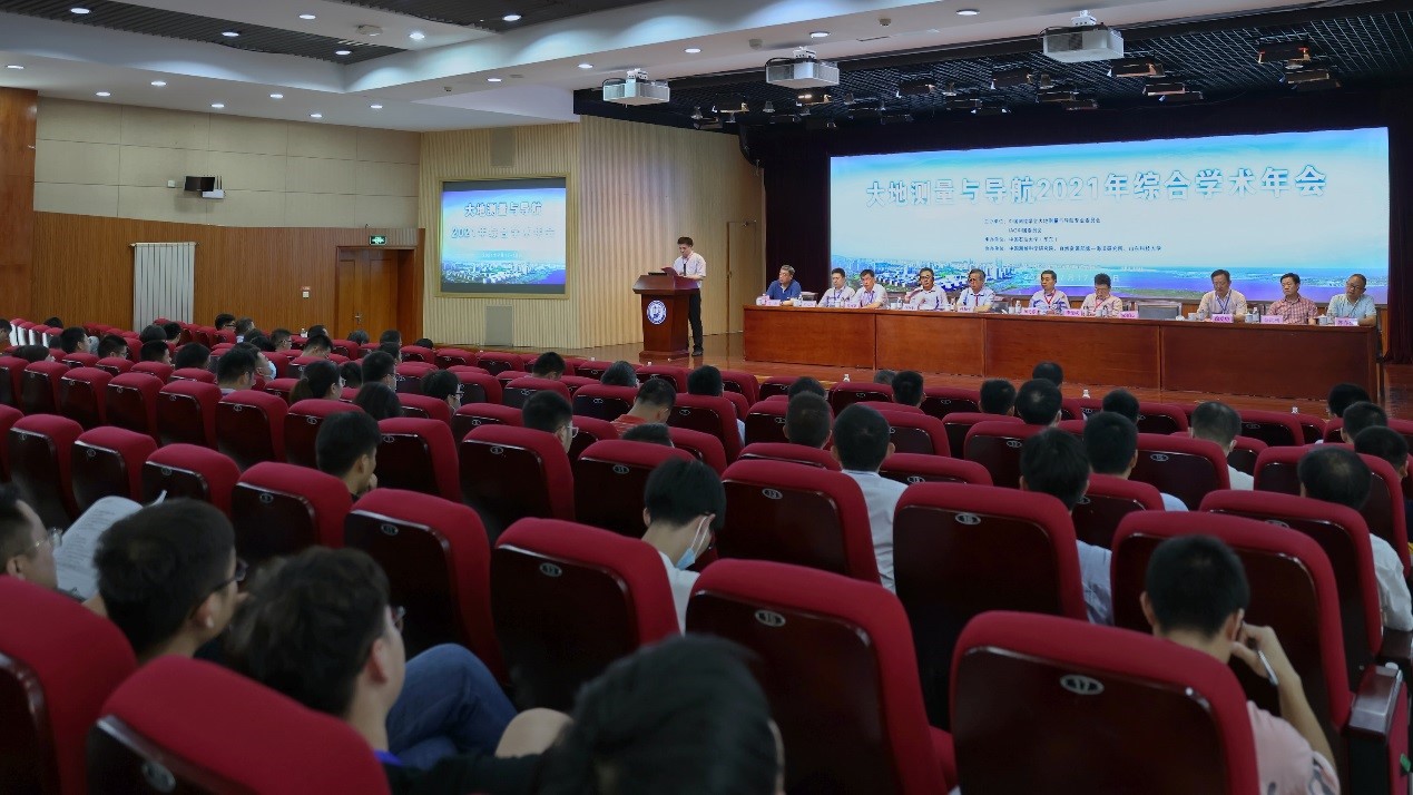
Opening ceremony
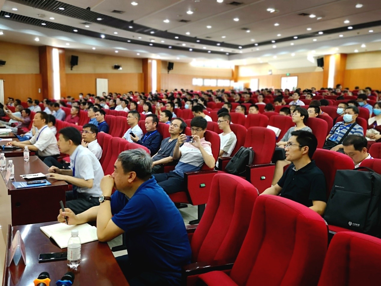
Oral session
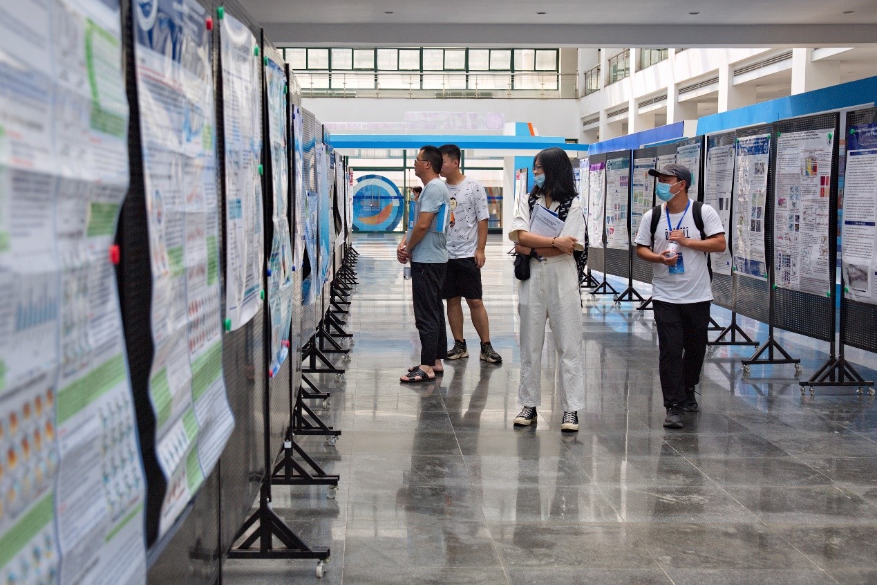
Poster session
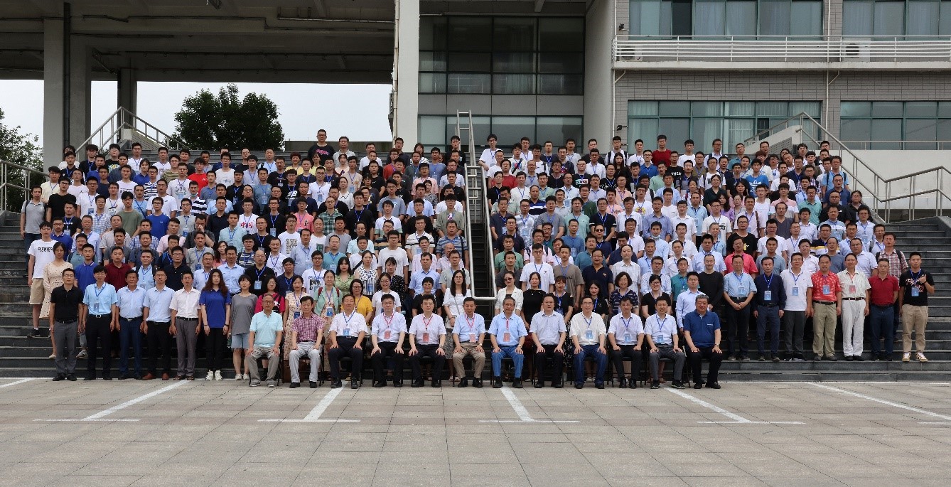
Participants of the Chinese Annual Geodetic General Assembly 2021
Reported by Tao Jiang, Shuqiang Xue and Yamin Dang from CNC-IAG, July 23, 2021
Obituary
Andrzej Borkowski (1959 - 2021)
Prof. dr hab. Andrzej Borkowski passed away on March 13, 2021 in Wrocław. With his merits, he remarkably contributed to the strengthening of Polish-German scientific cooperation, to a significant expansion of knowledge in the field of geodata modeling and processing of geodetic observations, as well as the education of a few generations of engineers, masters, and PhDs in the fields of surveying, geodesy, remote sensing, and cartography.
Prof. Andrzej Borkowski was a full professor and the Director of the Institute of Geodesy and Geoinformatics at the Wrocław University of Environmental and Life Sciences (UPWr), Poland. In addition, he was a member of the University Senate, a member of the Committee of Geodesy of the Polish Academy of Sciences (PAN), and the corresponding member of the German Geodetic Committee (DGK) of the Bavarian Academy of Sciences and Humanities (BAdW).
Prof. dr hab. Andrzej Borkowski was born on October 7, 1959 in Łuków, Poland. He passed his matriculation examination in 1979 after graduating from the Geodetic Technical School in Żelechów. In 1984, he graduated with summa cum laude in geodesy at the Faculty of Melioration at the Agricultural University in Wrocław (now: Faculty of Environmental Engineering and Geodesy, Wrocław University of Environmental and Life Sciences), obtaining a Master's-Engineer degree.
He received his doctorate in technical sciences in 1994 at the Technical University of Dresden, Germany, on the basis of the dissertation entitled “Stochastisch-geometrische Beschreibung, Filterung und Präsentation des Reliefs” (Stochastic-geometric description, filtering and presentation of the relief). In 2004, he obtained the degree of habilitated doctor in the field of technical sciences, in the discipline of geodesy and cartography, in the specialization of geodesy on the basis of the habilitation thesis entitled “Modellierung von Oberflächen mit Diskontinuitäten” (Modeling of surfaces with discontinuities) also at the Technical University of Dresden. In February 2013, he received a professorship in technical sciences from the President of the Republic of Poland.
Prof. dr hab. Andrzej Borkowski focused his research on the methods of obtaining and modeling geodata. An important area of his scientific activity included the processing, filtering, and modeling of airborne and terrestrial laser scanning data and point clouds obtained from airplanes and unmanned aerial vehicles (UAVs). Within his research interests, he also focused on the issues of data integration from various sensors, in particular airborne laser scanning and radar interferometry (interferometric synthetic aperture radar, InSAR), and the use of these data in environmental research, land subsidence analysis in mining areas, and related to mass movements on the earth's surface. He published many papers in scientific journals, including those in Journal of Geodesy: “Global and local methods for tracking the intersection curve between two surfaces”, “Modelling of irregularly sampled surfaces by two-dimensional snakes”, “Thin plate spline interpolation” (all co-authored with Prof. Dr. Wolfgang Keller). In 2011, Andrzej Borkowski, together with Prof. Dr. Siegfried Meier, published a book in German about processing and visualization of data in geosciences and stochastic analysis: “Geometrie Stochastischer Signale” (The Geometry of Stochastic Signals).
Prof. dr hab. Andrzej Borkowski was the principal investigator of five national grants funded by Polish institutions and five further research projects carried out in cooperation with the Technical University in Dresden and the University of Stuttgart, and with the support of the European Space Agency and the Deutsches Zentrum für Luft- und Raumfahrt (DLR). In addition, he managed one project under the Climate-KIC program and remarkably contributed to the development of the European Plate Observing System for Poland (EPOS-PL).
He also completed numerous internships at universities in Germany and Austria. Prof. Andrzej Borkowski received scholarship of DAAD (Deutscher Akademischer Austauschdienst), the Saxon Ministry of Science and Art, and the TEMPUS program.
Prof. dr hab. Andrzej Borkowski has promoted nine PhDs. His didactic activity was also very intense. During his work as an academic teacher, he conducted lectures and classes in over a dozen professional subjects, both in engineering and master's studies, as well as in doctoral and postgraduate studies. He was a lecturer of courses, such as “Adjustment Theory”, “Laser Scanning Technology”, “Advanced methods of observation elaborating”, “Mapping with unmanned aerial systems”. He was the supervisor of about eighty master’s theses.
In the years 2006−2009, he was the head of the Department of Foundations of Geodesy at UPWr, and afterward, the head of the Department of Cartography, Photogrammetry and Geoinformatics and the Director of the Institute of Geodesy and Geoinformatics (since 2009). He had professional geodetic qualifications in the field of surveying and cadastral surveying. Since 2015, He has been a member of the Editorial Board of the journal Acta Gedynamica et Geomaterialia (published by the Institute of Rock Structures and Mechanics, Czech Academy of Sciences). He was a Board Member of the Polish Society for Photogrammetry and Remote Sensing and the Coordinator of cooperation with the Commission I of the International Society for Photogrammetry and Remote Sensing (ISPRS) - Sensors Systems. He was also a member of the International Association of Geodesy. Prof. Andrzej Borkowski was awarded with the "Lohrmann-Medaille" Medal by the Rector of the Technical University of Dresden. In 2007, he was awarded the Bronze Cross of Merit by the President of Poland.
In 2017, Prof. Borkowski became the corresponding member of the German Geodetic Committee (Deutsche Geodätische Kommission, DGK) of the Bavarian Academy of Sciences and Humanities (Bayerische Akademie der Wissenschaften). In 2020, he was elected a member of the University Senate.
He died in Wrocław on March 13, 2021, after a long disease, and rested in peace in the St. Anna Cemetery in Opole - Czarnowąsy. We are going to miss his tremendous sense of humor and brilliant answers to all questions in every situation.
Krzysztof Sośnica
The IAG Newsletter is under the editorial responsibility of the Communication and Outreach Branch (COB) of the IAG. It is an open forum and contributors are welcome to send material (preferably in electronic form) to the IAG COB (newsletter@iag-aig.org). These contributions should complement information sent by IAG officials or by IAG symposia organizers (reports and announcements). The IAG Newsletter is published monthly. It is available in different formats from the IAG new internet site: http://www.iag-aig.org.
Each IAG Newsletter includes several of the following topics:
- news from the Bureau Members
- general information
- reports of IAG symposia
- reports by commissions, special commissions or study groups
- symposia announcements
- book reviews
- fast bibliography
| DOCUMENTS |
| IAG_Newsletter_August_2021.pdf |