February 2023

General Announcements
- IUGG General Assembly Berlin 2023
- GGOS Portal Survey
- International Evaluation of the Finnish Geospatial Research Institute (FGI)
Meetings Calendar
IAG Sponsored Meetings
- 2nd Workshop of the Intercommission Committee on Geodesy for Climate Research (ICCC)
- EUREF Symposium 2023
- IUGG Berlin 2023
- GGOS Days 2023
- ILRS Technical Workshop 2023
Geodesy Related Meetings
- Munich Satellite Navigation Summit 2023
- European Navigation Conference 2023
- FIG Working Week 2023
- Bologna-VLBI: Life begins at 40!
- AOGS 20th Annual Meeting
- 13th Session of UN GGIM
General Announcements
IUGG Berlin 2023
The 28th IUGG General Assembly (IUGG2023) will be held from 11 to 20 July 2023 at the CityCube in Berlin, Germany.
This General Assembly is a special opportunity for participants from around the world to come together and discuss the full range of geodetic and geophysical themes, and further enhance the important interdisciplinary collaboration for a better understanding of our Earth System. IUGG2023 will provide a platform for personal meetings, exchange of ideas and developing new concepts for international science collaboration, all of which have suffered a setback during this pandemic crisis. IUGG2023 will help to create a new spirit to address pressing large societal challenges such as global environmental change and natural hazards and to stimulate novel geoscience research.
Important Dates
17 March 2023
- Abstract/grant acceptance sent to participants
11 April 2023
- Complete scientific program and guidelines for presenters published
28 April 2023
- Early-bird registration closes
02 May 2023
- Newsletter on field trips and accommodation reservations
- Final Adjustment of program
IUGG2023 Local Organizing Committee and Scientific Program Committe
GGOS Portal Survey
The services of the International Association of Geodesy (IAG) provide very important and valuable geodetic data, information, and data products that are increasingly relevant for Earth System research, including monitoring of global change phenomena and a wide range of diverse applications such as satellite navigation, surveying, mapping, engineering, geospatial information systems, and so on.
Currently, it is difficult for many people to obtain an overview of all available geodetic products and data. The Global Geodetic Observing System (GGOS) of the IAG aims to fill this gap by developing the GGOS-Portal, which will serve as a central search and access point for geodetic data and products (one-stop shop). Data and products will be described by detailed metadata and remain physically located at their originating data centers of each contributing IAG service and other data providers. The GGOS-Portal will only synchronize the provided metadata and include it in its platform to ensure better discoverability. In the long term, the GGOS-Portal can provide a set of tools for organized knowledge search, including visualization to support identification and selection of appropriate resources (information, data, products).
In general, geodetic data portals are a dime a dozen. However, the GGOS portal will be much more than just a data portal for geodetic data from the IAG Services. The combination of the easy understandable descriptions of products and observation techniques with this comprehensive source of detailed geodetic metadata makes the future GGOS portal unique.
GGOS is now conducting a survey to inquire the opinions of geodetic data users on data availability and visibility and to identify requirements for a comprehensive and user-friendly GGOS-Portal. In addition GGOS will obtain an overview of the current availability of data products and their metadata. Please take 10 to 15 minutes and participate in this survey to help us developing the GGOS Portal, a future unique access point for geodetic data and products: https://ggos.org/portal/
Martin Sehnal
GGOS Coordinating Office
International evaluation of the Finnish Geospatial Research Institute FGI
The results of the International evaluation of the Finnish Geospatial Research Institute FGI were published in February 2023. The evaluation was commissioned by the Ministry of Agriculture and Forestry (MAF). The evaluation panel was chaired by Professor Keijo Hämäläinen, the Rector of the University of Jyväskylä, Finland, and the international experts were Professor Dieter Fritsch, Stuttgart, Germany, Professor Anna Jensen, Copenhagen, Denmark and Professor Sandra Verhagen, Delft, the Netherlands. They became familiar with the current research within and outside the FGI based on the materials delivered in advance as well as through a two-day site visit in November 2022.
The Finnish Geodetic Institute (FGI) was established in 1918, and it remained an independent governmental research institute under the Ministry of Agriculture and Forestry until 2015 when it was merged with the National Land Survey (NLS) as a research unit. The name was changed to the Geospatial Research Institute FGI, but its tasks and guiding ministry remained the same.
The FGI is a research and expert unit within the NLS that carries out research and development in geodesy, positioning, navigation, cartography, geographic information sciences, photogrammetry and remote sensing. It provides basic research and a scientific basis for Finnish maps, geospatial information and positioning, and cooperates with national and international institutions. Department of Geodesy and Geodynamics is one of the four departments of the FGI.
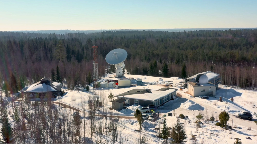
Metsähovi Geodetic Research Station. The gravimetric laboratory is at the left, the new VGOS radio telescope in the centre and the SLR observatory at the right. Behind it is the new main building.
The Metsähovi Geodetic Research Station is a key infrastructure of the FGI. Metsähovi is the basic station for the national reference system, a part of the National permanent GNSS network FinnRef, and the basic points of the national height system and the Finnish gravity system are in Metsähovi. Internationally, Metsähovi is a stable part of a global geodetic network used in maintaining global terrestrial and celestial reference frames, for computation of satellite orbits, and for geophysical studies. During the last decade, all major measurement systems were renewed or updated. This includes the construction of a new VLBI Global Observing System (VGOS) system, a new SLR system and improvement of the station infrastructure and working facilities. Operations in Metsähovi also directly support the United Nations General Assembly 2015 resolution "Global Geodetic Reference Frame for Sustainable Development".
Eight years after the merger, the MAF decided to arrange an international evaluation of the FGI. The previous evaluation was arranged 25 years ago, and the ministry wanted to see what kind of development had taken place and what the merger had affected. The objectives of the evaluation were to get an independent expert view of the FGI and the quality of its scientific research, and to evaluate impacts and benefits for society.
In their report, the evaluation panel stated that the research and expert work carried out by the FGI is at an exceptionally high international level compared with similar (European) institutes. This is supported by the high number of publications and citations, and a large amount of external funding. As a strength, they mention that the FGI has got a worldwide reputation in geodesy, GNSS, laser scanning technologies, remote sensing, UAV, and geoinformatics. The high reputation has been a characteristic feature of Finnish geodesy that the leaders and the staff of the FGI have continuously been outstanding scientists, and also by a large number of positions of trust held by FGI employees in the international scientific community. The Metsähovi Geodetic Research Station is unique, at a national and international level, and therefore contributes to FGI being a competent and globally sought-after partner.
As a weakness, the panel mentioned that the total funding of the FGI depends heavily on external research programs, at the national and European levels. Quite often short-term external funding cannot offer mid-term and long-term contracts for young scientists, which makes recruitment difficult. One of the recommendations was that the long-term operations with adequate staffing and regular instrument upgrades of the Metsähovi Geodetic Research Station should be guaranteed.
The whole evaluation report (in English) can be found on the MAF website, https://mmm.fi/-/kansainvalinen-arviointi-suomen-paikkatietotutkimus-on-maailman-huipputasoa?languageId=en_US
Markku Poutanen
Finnish Geospatial Research Institute FGI of the NLS
Meetings Calendar
IAG Sponsored Meetings
- 2nd Workshop of Inter-Commission Committee on Geodesy for Climate Research (ICCC), March 28 – 30, 2023, online
URL: https://iccc.iag-aig.org/iccc-workshops/ws23 - EUREF Symposium 2023, May 22-26, 2023, Gothenburg, Sweden
URL: http://www.euref.eu/euref_symposia.html - IUGG Berlin 2023, July 11-20, 2023, Berlin Germany
URL: https://www.iugg2023berlin.org - GGOS Days 2023, September 20–22, 2023, Yebes, Spain
URL: https://ggos.org/event/ggos-days-2023/ - ILRS Technical Workshop 2023, October 16– 20, 2023, Arequipa, Peru
URL: https://ilrs.gsfc.nasa.gov/about/meetings.html
Geodesy Related Meetings
- Workshop in SAR for Geodesy, March 13-14, 2023, Finland, Online
URL: https://www.aalto.fi/en/events/workshop-in-sar-for-geodesy - Munich Satellite Navigation Summit 2023, March 13 – 15, 2023, Munich, Germany
URL: https://www.munich-satellite-navigation-summit.org/ - European Navigation Conference 2023, May 31-June 2, ESA ESTEC, Noordwijk, The Netherlands
URL: https://www.enc2023.eu - FIG Working Week, May 28 - June 1, Orlando, FL, USA
URL: https://www.fig.net/fig2023/ - Bologna-VLBI: Life begins at 40!, May 22-26, Bologna, Italy
URL: https://vlbi-40.ira.inaf.it/ - AOGS 20th Annual Meeting, July 30 - August 4, Singapore
URL: https://www.asiaoceania.org/aogs2023/ - 13th Session of UN GGIM, August 2-4, New York City, USA
URL: https://unstats.un.org/UNSDWebsite/events/
Further details are available in the IAG Event Calendar at: http://www.iag-aig.org/events.
The IAG Newsletter is under the editorial responsibility of the Communication and Outreach Branch (COB) of the IAG. It is an open forum and contributors are welcome to send material (preferably in electronic form) to the IAG COB (newsletter@iag-aig.org). These contributions should complement information sent by IAG officials or by IAG symposia organizers (reports and announcements). The IAG Newsletter is published monthly. It is available in different formats from the IAG new internet site: http://www.iag-aig.org.
Each IAG Newsletter includes several of the following topics:
- news from the Bureau Members
- general information
- reports of IAG symposia
- reports by commissions, special commissions or study groups
- symposia announcements
- book reviews
- fast bibliography
| DOCUMENTS |
| IAG_Newsletter_February_2023.pdf |