October 2023

General Announcements
- IAG resolution for the International Terrestrial Gravity Reference System (ITGRS)
- Virtual Meeting between IAG and UN-GGCE
Meeting Announcements
- 20th International Symposium on Geodynamics and Earth Tides
- Gravity, Geoid and Height Systems 2024
Meetings Calendar
IAG Sponsored Meetings
- 20th WEGENER Assembly 2023
- International School on the Geoid
- IVS 13th General Meeting and 25th Anniversary
- Gravity, Geoid and Height Systems 2024
Geodesy Related Meetings
- UN-GGIM Workshop
- International Symposium on Satellite Navigation: Advances, Opportunities and Challenges (ISSN2023)
- AGU Fall Meeting
- Recent Achievements and Future Perspectives in Geodesy
- EGU General Assembly 2024
- ION Pacific PNT Conference
- FIG Working Week 2024
- 45th COSPAR Scientific Assembly
- 32th IAU General Assembly
- 20th Geodynamics and Earth Tides Symposium (G-ETS 2024)
Reports
- Report on the GGOS Days 2023
General Announcements
IAG resolution for the International Terrestrial Gravity Reference System (ITGRS)
The International Association of Geodesy,
Noting,
- The importance of an International Terrestrial Gravity Reference System (ITGRS) for geodesy and geosciences,
- That with state-of-the-art absolute gravimeters a relative accuracy of 10-8 and better is achievable;
Acknowledging,
- The IAG resolution No. 9.2 and 16.3 adopted at the 18th IUGG General Assembly in Hamburg in August 1983, recommending the use of a common standard atmosphere and the zero-tide concept;
- The IAG Resolution No. 2 for the establishment of a global absolute gravity reference system adopted at the 26th IUGG General Assembly in Prague in July 2015,
- The IAG Resolution No. 4 on the establishment of the Infrastructure for the International Terrestrial Gravity Reference Frame, adopted at the 27th IUGG General Assembly in Montreal in July 2019,
Resolves,
- That the definition of the ITGRS be based on the instantaneous acceleration of free-fall expressed in SI and related to the zero-tide concept, a standard atmosphere, and Earth orientation in the ITRS (International Terrestrial Reference System),
Recommends,
- That the ITGRS be adopted as the reference system for gravity acceleration in geosciences and metrology,
Requests,
- That Commission 2 (Gravity Field) together with IGFS (International Gravity Field Service), BGI (International Gravimetric Bureau) and IGETS (International Geodynamics and Earth Tide Service) prepare and disseminate guidelines and conventions for the establishment of the International Terrestrial Gravity Reference Frame (ITGRF) as the realization of the ITGRS.
Virtual Meeting between IAG and UN-GGCE
The United Nations Global Geodetic Center of Excellence UN-GGCE will be hosting two listening sessions to maximize the opportunity for participation from IAG members all around the world. Both sessions will have the same agenda, so please choose which time suits you.
Concept Note
The vision of the United Nations Global Geodetic Centre of Excellence (UN-GGCE) is one where all countries have strong political support for geodesy which enables them to – together – accelerate the achievements of the Sustainable Development Goals and derive social, environmental and economic benefits. Our objective is to work with Member States and geodetic organizations to strengthen our collective impact to:
- Enhance investment in the global geodesy supply chain.
- Improve coordination and collaboration amongst Member States and geodetic organizations.
- Share geodetic data and improve standards, on a voluntary basis, to contribute to the global reference frame and regional densifications.
- Provide greater technical assistance, especially for capacity development in geodesy for developing countries.
- Make geodesy and its benefits more visible and understandable to society.
The UN-GGCE recognizes the important role the International Association of Geodesy (IAG) plays in the geodetic community. In particular, the enormous in-kind contribution IAG representatives and their respective Member States / organizations provide throughout the supply chain of infrastructure construction and operation, data collection, analysis, product development and data sharing. The UN- GGCE’s role is not to duplicate any of the work being done by the IAG. Instead, one of the UN-GGCE roles is to support IAG to continue to deliver on its mission and objectives.
The staff in the UN-GGCE would like to meet with IAG representatives, listen to you and better understand how we can assist you.
Participation
The “Listening World Tour” virtual meeting will be open to members of IAG.
Session A: 28th November 2023 | 07:00 UTC (11:00 UTC+4 / 16:00 UTC+9 / 18:00 UTC+11)
click here to register for the meeting
Session B: 28th November 2023 | 15:00 UTC (12:00 UTC -3 / 10:00 UTC-5 / 07:00 UTC-8)
click here to register for the meeting
More information
IAG Listening Tour – IAG Concept Note (Agenda, Registration) [PDF]
UN-GGCE
Nicholas Brown
Meeting Announcements
20th International Symposium on Geodynamics and Earth Tides
The G-ETS addresses the entire range of tidal phenomena and dynamics of the Earth, both on theoretical as well as on observational levels. The G-ETS focuses on Earth tides and non-tidal (atmospheric, oceanic and hydrological) loadings, Earth's time-variable rotation, and geodetic monitoring of reservoirs and volcanoes. Accent is also put on geodetic monitoring of surface deformation and mass redistributions sensed by various space techniques (GNSS, GRACE and GRACE-Follow-On, InSAR, etc.) as well as to innovative techniques and instruments (for instance cold-atom gravimeters) and their applications to monitoring the Earth's dynamics.
Preliminary scientific program and sessions
In keeping with previous G-ETSs, the following sessions are proposed:
- Tides and non-tidal loading.
- Geodesy for hazard monitoring (seismo- and volcano-geodesy, etc.).
- Monitoring of subsurface fluids (hydro-geodesy, hydro-gravimetry, geothermal monitoring, etc.).
- New technologies, software and innovative concepts (cold-atom gravimetry, gradiometry, etc.).
- Time variable gravity and mass redistribution (glacial isostatic adjustment, ice mass changes, ocean dynamics, etc.).
- Temporal variations of the Earth’s rotation.
The last day of the Symposium (Friday, August 30, 2024), will be dedicated to IAG business meetings.
Call for oral presentation and posters
The website for abstract submissions and registration will open in January 2024. A second circular will be sent in January 2024 to announce all deadlines and further details. Registration fees are expected with reduced rates for early bird, students, IAG members and retired scientists.
The abstract submissions and online registration will be hosted at the website https://gets2024.sciencesconf.org/.
Publications in special issues
Contributors to the symposium will be encouraged to submit a manuscript to two special issues, one in Pure and Applied Geophysics, the other one in Geodesy and Geodynamics. All submitted papers will undergo a review process. The deadline for full paper submission will be announced later.
Conference venue
The Symposium will take place at the University of Strasbourg, on the campus of Esplanade, easily accessible by tram or on foot (30 min) from Strasbourg railway station. Strasbourg railway station is reachable from Strasbourg-Entzheim airport by train. Exact location within the University of Strasbourg, Esplanade campus, will be provided later.
Accommodation
Strasbourg is a touristic city where you can find a broad range of hotels, bed-and-breakfasts and other accommodations, within walking distance or by tramway from the University of Strasbourg, Esplanade campus.
Local Organizing Committee
- Jean-Paul Boy, ITES Strasbourg
- Jacques Hinderer, ITES Strasbourg
- Séverine Rosat, ITES Strasbourg
Scientific Organizing Committee
- Christian Bizouard, SYRTE/Observatoire de Paris, France
- Janusz Bogusz, Military University of Technology, Warsaw, Poland
- Carla Braitenberg, University of Trieste, Italy
- Daniele Carbone, INGV Catania, Italy
- Sébastien Merlet, SYRTE/Observatoire de Paris, France
- Arttu Raja-Halli, National Land Survey, Finland
- Holger Steffen, Lantmäteriet, Sweden
- Hartmut Wziontek, Federal Agency for Cartography and Geodesy (BKG), Leipzig, Germany
General information
As the G-ETS 2024 is held under the umbrella of the IAG, travel grants can be directly solicited from the IAG (https://www.iag-aig.org/awards/210).
Please regularly check the conference website for updates and deadlines: https://g-ets2024.sciencesconf.org/
Gravity, Geoid and Height Systems 2024

Introduction
GGHS2024 continues the long history of IAG gravity field related symposia, initially hosted by the IAG Commission 2 (Gravity Field):
- GGG2000 (Banff, Canada),
- GG2002 (Thessaloniki, Greece),
- GGSM2004 (Porto, Portugal),
- GGEO2008 (Chania, Greece),
- GGHS2012 (Venice, Italy),
those organized by the International Gravity Field Service (IGFS):
- 1st IGFS Meeting 2006 (Istanbul Turkey),
- 2nd IGFS Meeting 2010 (Fairbanks, Alaska, USA),
- 3rd IGFS Meeting 2014 (Shanghai, China).
And more recently the joint IAG Commission 2 and IGFS Symposia:
- GGH2016 (Thessaloniki, Greece),
- GGHS2018 (Copenhagen, Denmark) and
- GGHS2022 (Austin, Texas).
On this occasion, GGHS2024 is co-organized by the IAG’s Global Geodetic Observing System (GGOS).
More information on the conference sessions, venue, and hosting city along with important dates for abstract submission, registration, trip and visa arrangements can be found in the symposium website at http://www.gghs2024.com.
Subjects – Themes
During the last decade, geodesy in general and gravity field modelling in particular, have experienced a notable growth in their recognition and end-product use by many scientific disciplines.
This was mainly due to the advent of the dedicated legacy satellite gravity missions of CHAMP, GRACE and GOCE, which have brought new insights to both the static and time-variable representations of the Earth’s gravity field. GRACE Follow-On has seamlessly integrated with the 15-year GRACE data record and has become indispensable for a wide variety of geophysical process and climate studies. New mission concepts, like NGGM, new accelerometers for satellite gradiometry, cold atom gravimetry, and new and enhanced processing technologies, shall substantially improve this knowledge with further increased spatial and temporal resolution. Moreover, the continuous availability of altimeters on-board satellites and the improvements in the representation of the marine geoid have provided higher accuracies to shorter spatial scales of the marine geoid and gravity field, ocean topography and circulation as well as the structure of the oceanic crust.
At the time came advancements in traditional terrestrial, airborne, UAV and shipborne gravity instrumentation, which offer considerable improvements in gravity networks and the monitoring of gravity variations. Absolute quantum gravimeters have emerged and are gradually replacing free-fall corner cube ones, concepts on quantum sensors are investigated as future payloads for gravity dedicated space missions, while results from gravimeters based on MEMS and airborne sensors on UAVs are emerging.
Another a major breakthrough for the gravity and geoid community has been the definition of the International Height Reference System (IHRS) and the practical realization of the International Height Reference Frame (IHRF). Concepts for geoid and potential determination have been developed and tested aiming at providing a roadmap for the definition and realization of physical heights into a worldwide frame. The latter can lead to the linkage of local vertical datums to a global one, which is fundamental for monitoring sea level variations, as well as engineering and hydrological and cryosphere studies.
The collocated use of the new datasets and models offered by gravity-field related research improves the knowledge of the Earth system, its sub-systems, coupling processes among them, which are important indicators for climate change. They provide the building blocks for innovative investigations of the solid Earth giving new details of crust and mantle and their variation in time.
Contributions on methods for observing, modelling and interpreting the Earth’s gravity field, the determination of the geoid, the establishment of physical height systems, and the essential role of gravity field modelling in measuring, understanding and predicting changes in the Earth system are welcomed for presentation at the GGHS2024 Symposium.
GGHS2024 sessions
- Session 1: Reference systems and frames in Physical Geodesy
- Session 2: Novel technologies in terrestrial, airborne and satellite gravity field determination
- Session 3: Static and time-variable global gravity field modelling
- Session 4: Regional gravity field modelling and geophysical interpretation
- Session 5: Gravity for climate, atmosphere, ocean and natural hazard research
- Session 6: Data management, dissemination of results and networking of stakeholders
G. Vergos
Meetings Calendar
IAG Sponsored Meetings
- International School on the Geoid, November 15-17, 2023, Buenos Aires, Argentina
URL: https://sirgas.ipgh.org/escuela-geoide/en/home-2/ - IVS 13th General Meeting and 25th Anniversary, March 4-8, 2024, Tsukuba, Japan
URL: https://www.youtube.com/watch?v=mQkA8VHKWD4 - Gravity, Geoid and Height Systems 2024, August 26 – 29, 2024, Thessaloniki, Greece
URL: https://www.gghs2024.com/
Geodesy Related Meetings
- UN-GGIM Workshop, November 7, Kuta Bali, Indonesia
Capacity Development Workshop on Geodetic Reference Frames, its Dynamics and Application for Geohazards
URL: https://apgf2023.id/ - International Symposium on Satellite Navigation: Advances, Opportunities and Challenges (ISSN2023), November 20-22, 2023, Jiaozuo, Henan,China
URL: http://218.196.240.235/SatelliteNavigation-ISSN2023 - AGU Fall Meeting, December 11-15, 2023, San Francisco, CA, USA
URL: https://www.agu.org/Fall-Meeting - Recent Achievements and Future Perspectives in Geodesy, February 21-22, 2024, Potsdam, Germany
URL: https://leibnizsozietaet.de/wp-content/uploads/2023/09/Colloquium_in_honor_of_Harald_Schuh-save-the-date.pdf - EGU General Assembly 2024, April 14 – 19, 2024, Vienna, Austria
URL: https://www.egu24.eu/ - ION Pacific PNT Conference, April 15-18, 2024, Honolulu, Hawaii
URL: https://www.ion.org/pnt/index.cfm - FIG Working Week, May 19-24, 2024, Accra, Ghana
URL:https://www.fig.net/fig2024/index.htm - 45th COSPAR Scientific Assembly, July 13-21, 2024, Busan, Korea
URL: https://www.cospar2024.org/ - 32th IAU General Assembly, August 6-15, 2024, Cape Town, South Africa
URL: https://astronomy2024.org/ - 20th Geodynamics and Earth Tides Symposium (G-ETS 2024), August 25-30, 2024, Strasbourg, France
URL: https://g-ets2024.sciencesconf.org/
Reports
Report on the GGOS Days 2023
GGOS convenes its various components annually to report on achievements and formulate activities for the future. On this occasion, the Instituto Geográfico Nacional of Spain hosted the GGOS Days in Alcalá de Henares from 20th to 22nd September 2023. The meeting was hybrid, enabling remote participation, and had 192 attendees, 40 of whom were present in person.
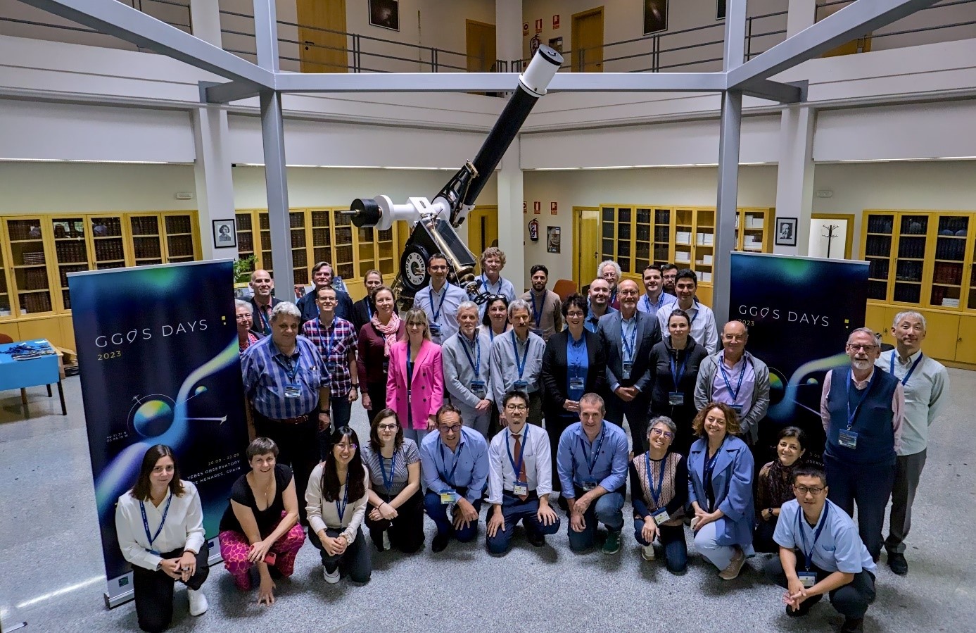
On-site participants in the GGOS Days 2023
The conference agenda included 10 sessions, beginning with a presentation by Spanish and Portuguese colleagues outlining the current status and future plans for space geodesy in their respective countries. Noteworthy was the informed decision to install the GGOS Affiliate Iberatlantic. The keynote speaker session featured three pertinent contributions on interesting geodetic subjects: (1) The contribution of superconducting gravimetry to Earth System observations; (2) Hydrodynamic levelling for modelling hydrodynamics in coastal regions; and (3) Glacial isostatic adjustment and its significance in geodesy. Additionally, a presentation on the usage of K-Band (24 GHz) in geodesy was given.
As GGOS Affiliate Japan celebrates its 10th anniversary, its major accomplishment is deploying the latest technology in Japanese fundamental geodetic observatories. The GGOS Affiliate D-A-CH focuses on creating methodologies that combine and integrate all geodetic techniques consistently. This goal enhances the precision and dependability of geodetic outcomes.
The GGOS External Activities presentations highlighted recent accomplishments of the UN Sub-Committee on Geodesy, perspectives for South America's involvement in GGOS, and the collaborative efforts of the IAG's Communication and Outreach Branch and the Coordinating Office of GGOS to enhance the visibility of the IAG and Geodesy. Initiatives promoting the FAIR (Findable, Accessible, Interoperable, and Reusable) data principles within the IAG were extensively discussed. Specifically, the utilization of DOIs for geodetic data and products and the implementation of the GGOS portal as a convenient one-stop-shop for all geodetic products from IAG and its various components were emphasized.
In the GGOS Bureau of Networks and Observations (BNO) session, the IAG Services presented recent achievements and new challenges objectively. This session provided a comprehensive overview of current Service activities. Additionally, the Committee PLATO (Performance Simulations and Architectural Trade-Offs) presented an update on recent simulations aimed at enhancing the geometric configuration of space geodetic reference stations. The Committee on Satellite Missions provided an assessment of the technical features and application areas of the newly sanctioned gravity mission MAGIC (Mass change and geoscience international constellation). The Committee on Data and Information Systems reported on the progress in deploying GeodesyML (Geodesy Markup Language), a tool that simplifies the manipulation of geodetic data and metadata, including those related to equipment, site logs, measurement, adjustment, quality, monuments, reference frames, and data lineage. The GGOS/IERS joint working group on Site Survey and Colocation shared information about the local ties that have been measured at 20 stations since 2020. The number of intra-technique vectors increased from 212 to 253.
At the GGOS Bureau of Products and Standards (BPS) session, after an overview presentation showing objectives, structure and activities of this Bureau, interesting discussions about the computation of a new reference level ellipsoid and the implementation of a catalogue with Essential Geodetic Variables were conducted. This session closed with a review of the Committee Contributions to Earth System Modelling.
Regarding the GGOS Focus Areas (FA), the FA Unified Height System presented a final report about the integration of its activities into the IAG Commission 2 (Gravity Field) and the IGFS (International Gravity Field Service). This FA was dissolved at the General Assembly of the IUGG (International Union of Geodesy and Geophysics) in Berlin in July 2023, having achieved its objectives. The FA on Geohazards presented a status report focused on the advancement of GNSS-based Tsunami Early Warning Systems (GTEWS) and the establishment of a GTEWS capability for the South Pacific's Oceania region. The FA on Geodetic Space Weather Research summarised accomplishments in four research areas, namely: the coupling processes among the magnetosphere, thermosphere and ionosphere; modelling of the electron density; development of thermosphere models; and comprehension of space weather events and their supervising through satellite missions. The recently established FA on Artificial Intelligence for Geodesy (AI4G) reported on strategies for the development and evaluation of improved geodetic products based on AI and machine learning. Specific presentations on AI for GNSS remote sensing, gravity field and mass change, prediction of Earth orientation parameters, and geodetic deformation monitoring were given. In addition, the topics and objectives of two new potential focus areas on the combination of tropospheric parameters and the integrated analysis of GNSS and InSAR data were discussed.
The remaining sessions were devoted to redefining the memberships of the GGOS management structure, following the customary practice within the IAG every four years.
The GGOS Days 2023 featured a technical visit to the Yebes Observatory, a notable scientific facility focused on astronomical and geodetic research and observation, and a key contributor to the IAG and its Services. The Yebes Observatory staff conducted a comprehensive tour of the recently installed equipment and facilities for the conference attendees over the course of an entire afternoon. The exceptional professionalism and friendly welcome of our colleagues at Yebes Observatory created an unforgettable visit.
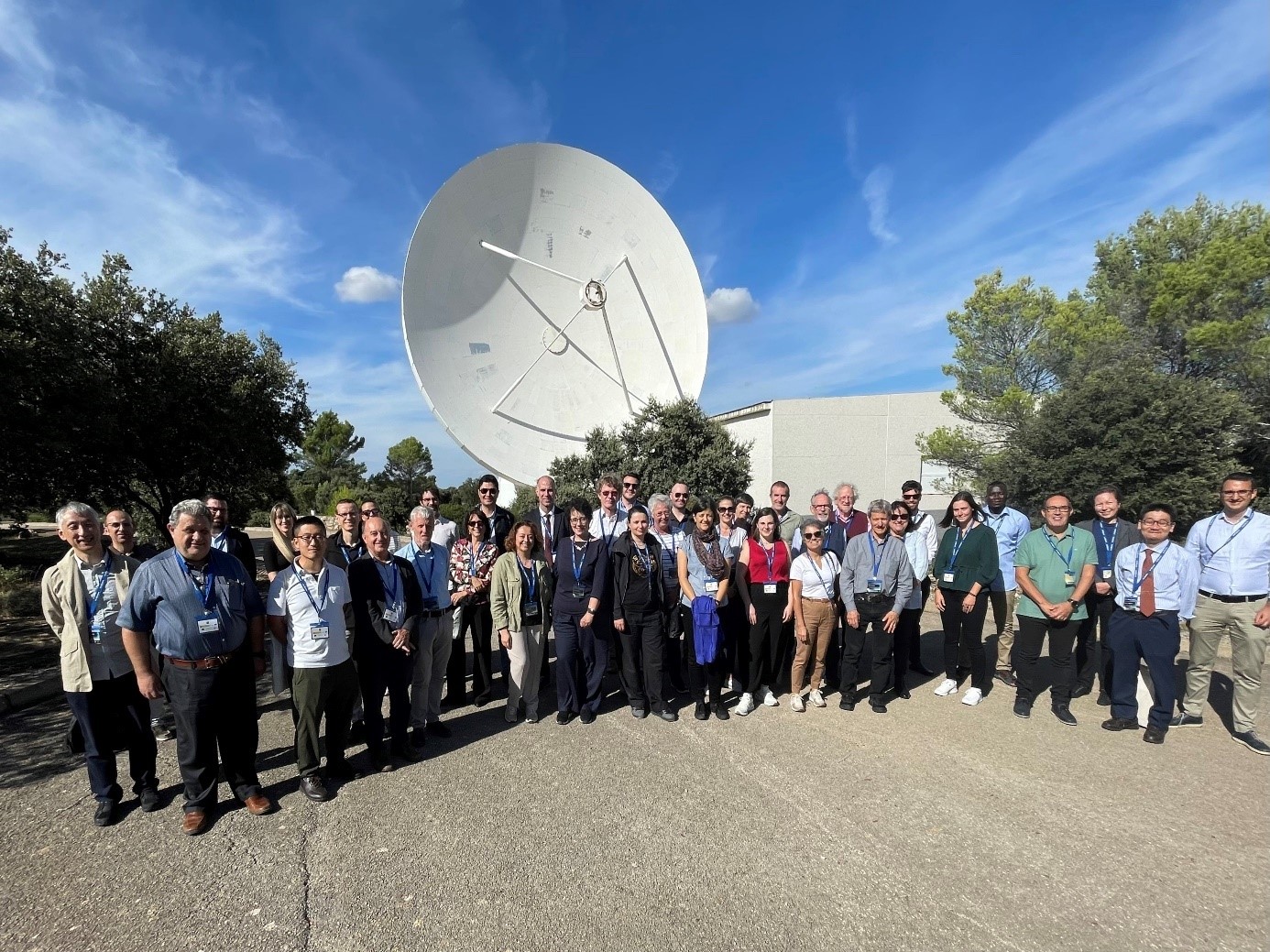
Visiting the Yebes Observatory
Further information regarding the GGOS Days 2023 conference, presentations, and outputs can be accessed at https://ggos.org/event/ggos-days-2023/.
We extend our sincerest gratitude to the Instituto Geográfico Nacional and the Yebes Observatory staff for their unwavering commitment in organizing this successful meeting. Moreover, we are thankful to the numerous speakers who, through their dedication and hard work, make GGOS possible. We would also like to thank all participants for their interest and active contribution to the discussion. Finally, we express our special gratitude to the IAG for providing travel awards to some participants, enabling them to attend this event.
Laura Sánchez, GGOS President, Deutsches Geodätisches Forschungsinstitut der Technischen Universität München (DGFI-TUM), Germany
José Antonio López Fernández, Chair of the Local Organizing Committee, Instituto Geográfico Nacional, Spain
Martin Sehnal, Director of the GGOS Coordinating Office, Federal Office of Metrology and Surveying, Austria
The IAG Newsletter is under the editorial responsibility of the Communication and Outreach Branch (COB) of the IAG. It is an open forum and contributors are welcome to send material (preferably in electronic form) to the IAG COB (newsletter@iag-aig.org). These contributions should complement information sent by IAG officials or by IAG symposia organizers (reports and announcements). The IAG Newsletter is published monthly. It is available in different formats from the IAG new internet site: http://www.iag-aig.org.
Each IAG Newsletter includes several of the following topics:
- news from the Bureau Members
- general information
- reports of IAG symposia
- reports by commissions, special commissions or study groups
- symposia announcements
- book reviews
- fast bibliography
| DOCUMENTS |
| IAG_Newsletter_October_2023.pdf |