
Description of the Global Geodetic Reference Frame
The United Nations General Assembly adopted the resolution on a Global Geodetic Reference Frame for Sustainable Development (A/RES/69/266) on February 26, 2015. The purpose of this document is a description of the Global Geodetic Reference Frame (GGRF), along with a brief description of its key components, as a realization of the Global Geodetic Reference System (GGRS).
Preamble
The United Nations General Assembly adopted the resolution on a Global Geodetic Reference Frame for Sustainable Development (A/RES/69/266) on February 26, 2015. The purpose of this document is a description of the Global Geodetic Reference Frame (GGRF), along with a brief description of its key components, as a realization of the Global Geodetic Reference System (GGRS).
This document forms the basis for a common understanding of the GGRF. It has been prepared by the International Association of Geodesy (IAG), the organization responsible for the science of geodesy. It thus outlines the IAG’s perspective of what the GGRF is, and how it is realized through the contributions of the IAG components.
The mission of the IAG is the advancement of geodesy – the Earth science concerned with the size, shape, gravity field, and orientation of the Earth, including their temporal variations. The IAG supports the design of new satellite missions for gravity field determination, ocean and ice altimetry, and Earth observation in general, as well as promoting the importance of modern geodesy for addressing the needs of science and society for a variety of spatio-temporal and gravimetric reference frames. The Global Geodetic Observing System (GGOS) was established by the IAG to be the component that integrates the various geodetic contributions to ensure the quantification of our planet’s changes in space and time with the highest accuracy and reliability. This is undertaken primarily through activities such as the maintenance, and continuous improvement of the geodetic instrumentation networks and space geodetic missions, and the combined analysis of geometric and gravimetric observations made by these networks using a variety of space and terrestrial geodetic techniques. In such a framework, the GGRF plays a key role in facilitating the integration of the different geometric and gravimetric observations, with the goal of providing reliable, high quality geodetic products and services.
The GGRF is intended to support the increasing demand for positioning, navigation, timing, mapping, and geoscience applications. The GGRF is essential for a reliable determination of changes in the Earth system, for natural disaster management, for monitoring sea-level rise and climate change, and to provide accurate information for decision-makers. Furthermore, due to globalization and interoperability requirements, there is a growing demand for spatial data infrastructure. Precise spatial information is needed in many areas of benefit to society, including transportation, construction, infrastructure, process control, surveying and mapping, and Earth sciences, and is especially important for monitoring progress towards the UN’s Sustainable Development Goals.
General Concept
The GGRF includes the geometry and gravity field of the Earth and the Earth's orientation with respect to the celestial reference frame. It is based on geodetic observing systems, data centers, analysis centers, as well as combination and product centers. While the concept of a GGRF predominantly focuses on infrastructural, operational and technical issues, associated research and innovation activities are also to be considered.
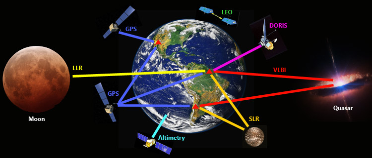
The bases for the realization of the GGRF are the multiple geodetic observation infrastructures. GGOS defines the observation architecture at several levels: terrestrial networks with geometric and gravimetric observation stations, artificial satellites, the moon and the planets, and extragalactic objects (see Fig. 1). The permanent availability of state-of-the-art geodetic infrastructure, and scientific and technical personnel to generate the resultant products and services, is crucial for a sustainable GGRF.
Global Geodetic Reference System
Geodetic reference systems are the mathematical and physical models necessary to describe physical positions and gravity in a space-time environment. Fundamental geodetic theories and methodologies provide the framework for the definition of geodetic reference systems.
The GGRS comprises terrestrial and celestial components. The terrestrial component is a common reference for the geometry and the gravity field of the Earth , where a physical point P has a corresponding coordinate X, potential of the Earth gravity field W, physical height H, and gravity vector g. The following specifications apply:
- For the physical point P the potential WP = W(X) is evaluated at the coordinate X in the International Terrestrial Reference System (ITRS).
- The unit of time is the SI second. The unit of length is the SI meter.
- The physical height is the difference −ΔWP between the potential WP of the Earth gravity field at the considered point P and the geoidal potential of the level ellipsoid W0.
- The gravity vector g is the gradient of the potential of the Earth gravity field.
- Geometry and gravity are implicit functions of time.
- Fundamental parameters and conventions for the use of models, for example, the tidal system, and procedures are required.
The International Celestial Reference System (ICRS), based on a kinematic definition, is a quasi-inertial system. The ICRS provides the celestial foundation for the GGRS. The relationship between the ITRS and the ICRS is described by the Earth Orientation Parameters (EOP). The EOP are not only relevant as transformation parameters between the ITRS and the ICRS, but also for relating geometric and gravimetric quantities in a variety of ways.
Global Geodetic Reference Frame
The Global Geodetic Reference Frame (GGRF) is the realization of the Global Geodetic Reference System (GGRS), made possible through physical points on the Earth’s surface, satellites in near-earth orbit, and celestial objects, along with parameters describing geometry and gravity over time.
The network of terrestrial points is global, with national and regional densification of the geodetic infrastructure. This network of GGRF stations typically comprises:
- fundamental geodetic observatories employing all space geodetic techniques co-located with gravimetric instruments, enabling the connection between X, W, and g;
- other geodetic stations also including reference tide gauges, height datum points, and gravity measurement points co-located where possible with space geodetic instruments.
Fundamental geodetic observatories also include precise and stable time-keeping instruments and should be connected to time reference stations (in future using optical clocks for ΔW determination — relativistic geodesy) and gravity reference stations (equipped with absolute and superconducting gravimeters, see IAG Res. 2015 No. 2).
All GGRF stations must be:
- continuously operated, over the long-term, to ensure the stability of the GGRF;
- equipped with state-of-the-art observation technology so as to produce high quality measurements of geodetic quantities;
- continuously monitored to detect surface deformations of the Earth; and
- connected to height datums to precisely relate their geopotential differences for vertical datum unification.
The ITRS is realized by the International Terrestrial Reference Frame (ITRF) consisting of positions and time variations of network stations observed by space geodetic techniques such as VLBI, SLR, GNSS, and DORIS. Crucial for the integration of the different techniques are globally-distributed co-location sites with accurate local tie vectors.
The ICRF is a realization of the ICRS consisting of the positions of compact extragalactic objects, mostly quasars. These natural radio sources are sufficiently far away such that their expected proper motions are negligibly small. The ICRF is realized by VLBI observations at terrestrial network stations. Furthermore, the operability of the GGRF requires international standards and specifications for the exchange of measurements and products, and the use of harmonized models, parameters, and procedures.
For the realization and maintenance of the GGRF, an operational infrastructure in the form of international services and scientific organizations is needed. Currently the IAG Commissions and Services are responsible for the implementation of the UN Resolution on a Global Geodetic Reference Frame for Sustainable Development. The development of an integrated mechanism for the establishment and maintenance of the GGRF is one of the key GGOS goals. Hence the IAG will continue to play a leading role in defining the strategies and methodologies for the implementation of the GGRF.
Implementation Steps Towards the GGRF
The GGRF is an integrated geodetic reference frame, incorporating the ITRF and the ICRF, the future International Height Reference Frame (IHRF), and the new global absolute gravity network (IGSNn) according to IAG Resolutions 2015 No. 1 and No. 2, respectively. The combination of the IHRF and the ITRF requires the Global Gravity Model (GGM). The GGM is derived by measurements from satellite gravity and altimetry missions, complemented with terrestrial gravity data. For the development of the IHRF, an IAG Joint Working Group will be established. To replace the International Gravity Standardization Net 1971 (IGSN71) with the IGSNn, a Working Group will define a geodetic gravity reference system based upon the international comparisons of absolute gravimeters. The globally-distributed reference stations of the IHRF and of the IGSNn, including the stations for international comparisons of absolute gravimeters, have to be linked to the fundamental geodetic observatories for co-location of gravity reference stations with space geodetic instruments.
With the resolution on a Global Geodetic Reference Frame for Sustainable Development the UN Member States are requested to:
- encourage, together with relevant international organizations, global cooperation in providing technical assistance, especially for capacity development in geodesy for developing countries;
- openly share geodetic data, standards, and conventions, through relevant national mechanisms and intergovernmental cooperation, and in coordination with the IAG;
- maintain, and improve their national geodetic infrastructures;
- engage in multilateral cooperation that addresses infrastructure gaps and duplications; and
- assist in the development of outreach programs that make the GGRF more visible and understandable to society.
The tasks for the IAG and its GGOS in the framework of the GGRF therefore are to:
- organize the IAG Services on a high scientific and technical level;
- support the development of geodetic technologies and products on the basis of open sharing of geodetic data, products, standards, and conventions;
- provide scientific leadership to all scientific organizations, national geodetic agencies, and Member States, on geodetic matters; and
- develop and improve theories and methodologies for the implementation of the GGRF.